
The Changing Form of Troy Town Maze
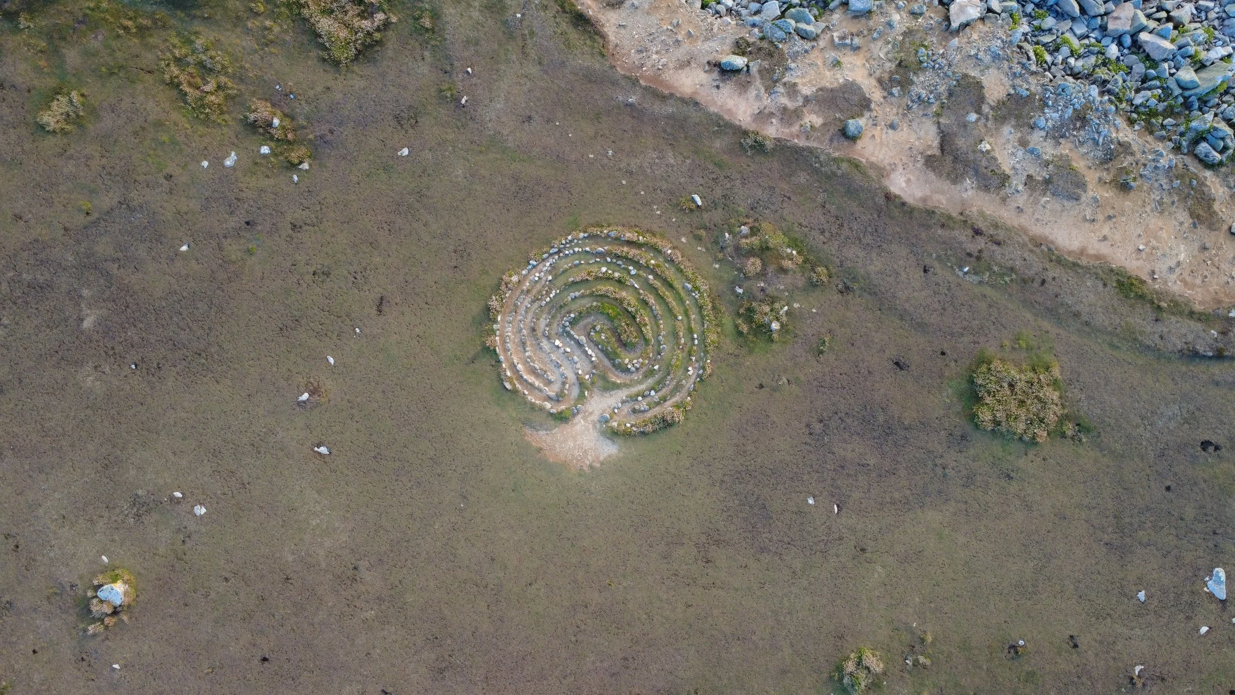
While designing our Scilly Labyrinths Trail (a simple guide to the locations of Scilly’s mazes available to download here), we made the discovery that - despite being Scilly’s oldest and most famous labyrinth - there seemed to be no recent photographs of Troy Town Maze from directly above. At least none that we could find online. As well as wanting to represent the labyrinth accurately on our trail, we wanted to understand how this maze has morphed and changed over the years, which was hard to see without either an accurate survey or an arial photo. So we took our little photography drone over on the supper boat to St Agnes and flew it over the maze one evening:
Creating the resulting image (below) was oddly moving - revealing a new vantage point on this old and special site that only sea-birds (and maybe fairies? if the stories are to be believed) would have known until now. Labyrinth symbology is so potent and magical, and being able to see the true shape of this one - the oldest and most genuinely mysterious on the islands - was a real moment of awe, which - for us at least - reinforces the understanding of this place as a special and sacred site.
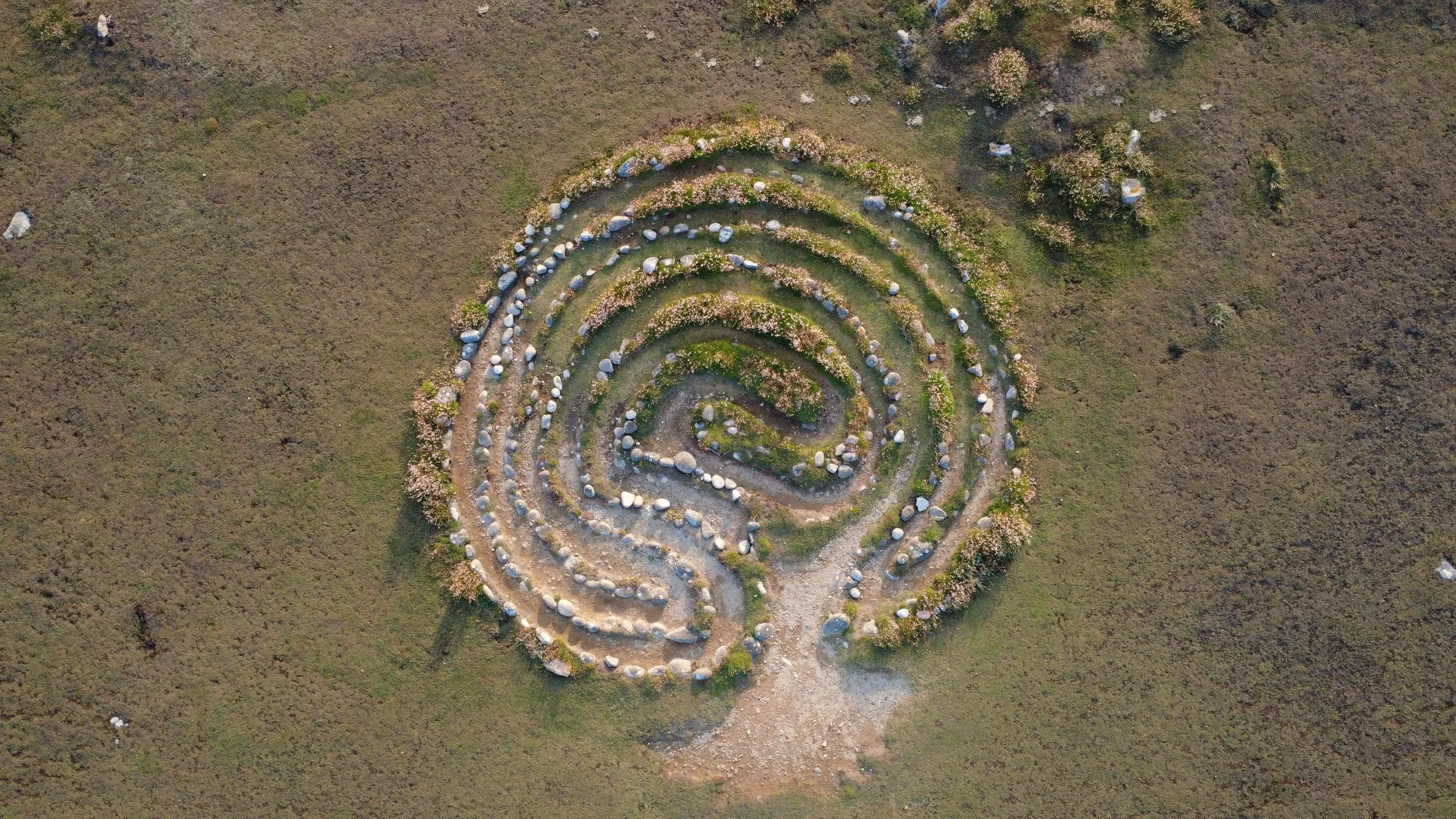
Our drone photograph of Troy Town Maze in its current form, Summer 2025.
We were also surprised to see that the labyrinth is still very round, and it’s shape actually hasn’t seemed to have changed much at all, despite the constant walking and the unfortunate replacement of stones (despite Troy Town Maze’s status as a Scheduled Historic Monument, which makes any such tampering illegal, tourists have been known to remove the worn sea-pebbles from the maze to keep as souvenirs, replacing them with nearby rocks that are more jagged in shape).
In ground-level photographs the maze appears to be quite ovoid, as the images below illustrate, and we presumed that the constant walking of the paths could have changed the previously round pattern to any new shape. But our drone image revealed that actually the maze is still quite circular.
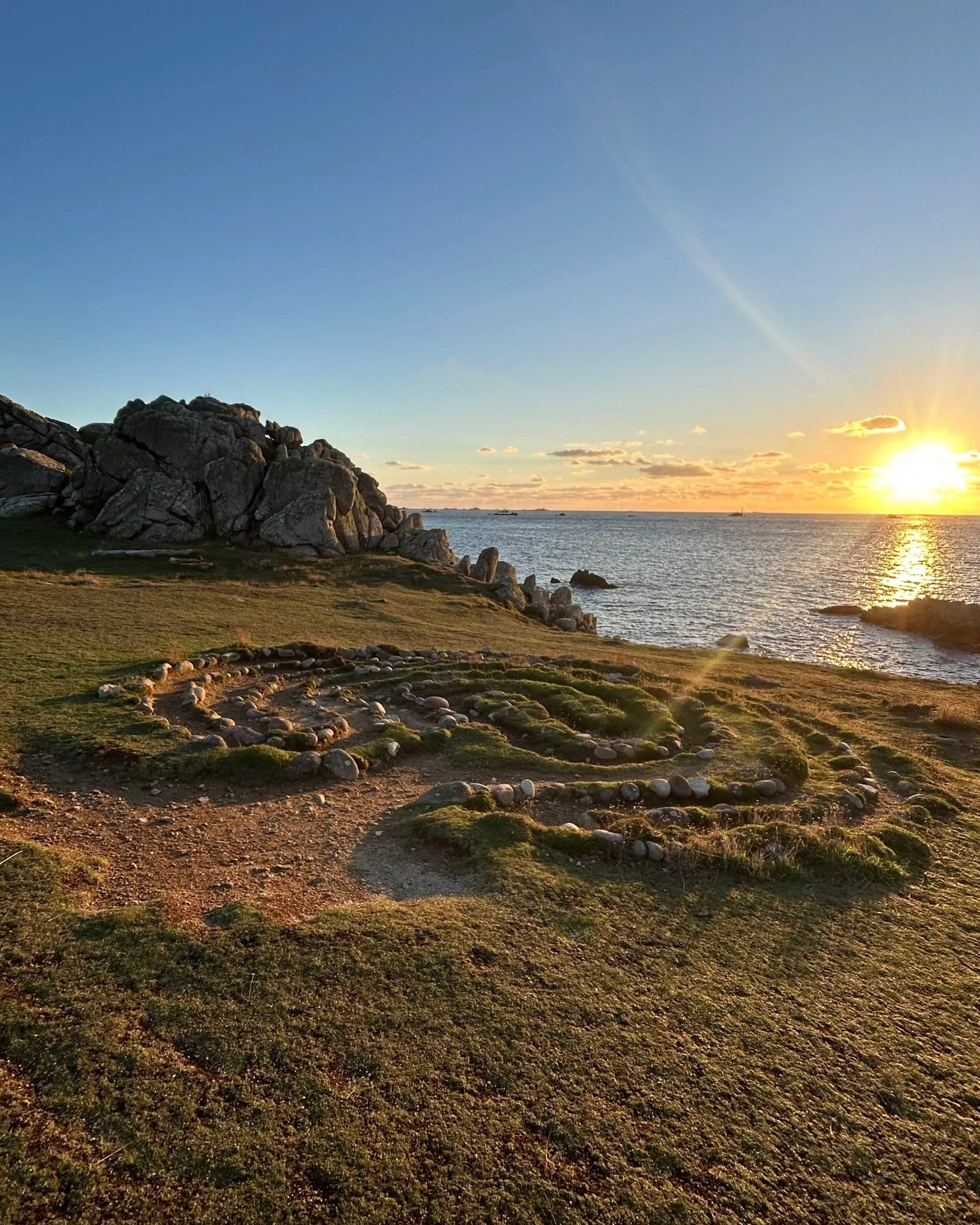
Troy Town Maze, appearing ovoid from ground level, facing out to sea, Summer 2025
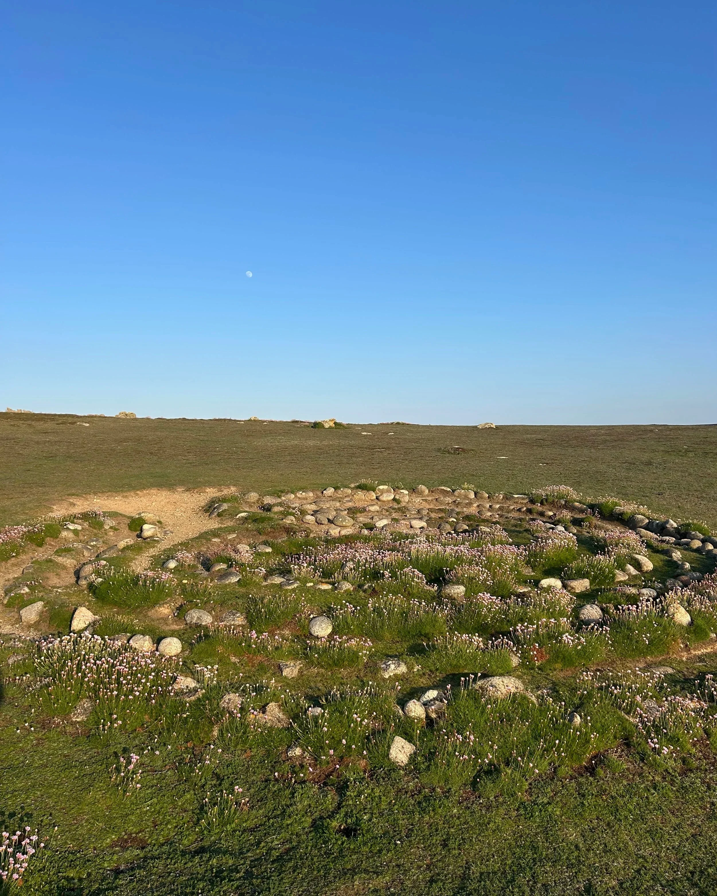
Troy Town Maze, appearing ovoid from ground level, facing inland, Spring 2025
While - to our knowledge - no other photographs of Troy Town Maze exist from directly above, we are lucky in that there are several drawings of the site we can look at, to understand how the shape has changed. In his fantastically in-depth article The Isles of Scilly Troy Towns (originally published in Caerdroia 47 (2018), p.38-53), labyrinth expert Jeff Saward charted the changing shape of Troy Town Maze over the years, from 1885, through 1983 to 1990, when it had been restored by a team of dowsers.

The changing design, size and orientation of the St. Agnes Troy Town in 1885, 1983 and 1990. Drawings by Jeff Saward, 1990.
Originally published in Caerdroia 47 (2018), p.38-53.
By comparing Jeff Saward’s 1990 drawing with our drone photograph we can see that the shape has become altered over time, particularly around the centre of the labyrinth. While still visible as a unicursal classical labyrinth (a shape associated with Cretan labyrinths, due to its appearance on early coins there) the paths have become more rounded and the overall shape feels much more organic, than the classical original form. By looking at our photographs, it is also possible to get a better understanding of how the 1885 labyrinth became changed to the shape it was in 1983, where it had begun to turn mazey, and there was no longer only one path and one centre. Comparing these images reminds me of the way that oxbow lakes are created by river meanders (thanks Year 8 Geography!) with the same erosion and deposition of materials (in our case caused by walking, rather than water-movement) carving out a new, more organic design for the paths overt time. In this way natural, physical, almost geological process are changing the maze, and while these changes are caused almost entirely by the movement of people, they are very much predetermined by the environmental and geographical makeup of the island.
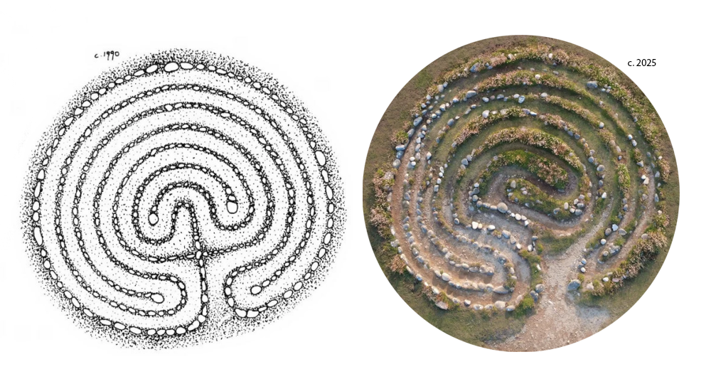
Comparing Jeff Saward’s 1990 sketch of Troy Town Maze from Caerdroia Magazine alongside our 2025 drone image.
Seeing the old maze from this viewpoint - flanked with eruptions of frothing sea-thrift and positioned beside the rocky coast - as well as shining new insight into how the shape is slowly transforming, really illustrates how the maze has become part of the landscape of the island. It has been a collaboration between people and environment over at least 300 years that created this site. It appears to be not wholly a human thing, and not wholly a natural thing either, but something that straddles that magical space in between.
Another drone photograph of Troy Town Maze in its current form, Summer 2025.